To use groundwater for irrigation or other commercial purposes, you must have a ‘take and use’ licence.
How to apply
To get a ‘take and use’ licence you can either:
1. Apply for a new licence
![]() Licence to take and use groundwater and operative works TU1 (271kB)
Licence to take and use groundwater and operative works TU1 (271kB)
2. Apply to renew your existing licence
![]() Renew a Licence to Take and Use Groundwater and Operate Works GWR1 (266kB)
Renew a Licence to Take and Use Groundwater and Operate Works GWR1 (266kB)
3. Transfer an existing licence from another landowner
![]() Permanent or temporary transfer of water for a take and use licence TU3 (358kB)
Permanent or temporary transfer of water for a take and use licence TU3 (358kB)
![]() Transfer of licence ownership on the sale of land TOL1 (234kB)
Transfer of licence ownership on the sale of land TOL1 (234kB)
If you no longer need your ‘take and use’ licence, you can surrender it:
![]() Surrender a licence to take and use water and operate works TU4 (217kB)
Surrender a licence to take and use water and operate works TU4 (217kB)
Further information...In the interests of the environment, the community and fairness, it's important for people to follow the rules regarding taking and using rural water. Many people taking and using rural water illegally may not realise they're doing so. It's essential that you, as a rural water user, understand your rights and obligations concerning our water resources.
Water costs vary depending on a number of factors and can change from year to year. |
Find out how to locate our underground assets. Use an interactive online map to find our assets.
Locate our underground assetsIf you're planning to build, construct, renovate or start any other works on land that may be near GWMWater's assets, you need to locate those assets first. |
Interactive map of GWMWater assetsUse our online interactive map to:
|
If you're planning to build, construct, renovate or start any other works on land that may be near GWMWater's assets, you need to locate those assets first.
What to do
Step 1: Call 'Dial Before You Dig' on 1100
No matter the size of your project (landscaping the front garden or developing a big block of your land) the first thing to do is call Dial Before You Dig, which is a free service for locating underground utilities anywhere in Australia. They'll advise you if there are any GWMWater assets near where you plan to dig (as well as other utilities such as telecommunications or gas).
Step 2: If you need more detailed information, use our interactive map or contact us
If Dial Before You Dig indicates there are GWMWater assets nearby, you may need more detailed information before you can start your works. You can either use our interactive map or get in touch with us.
Responsibilities for locating GWMWater assets
GWMWater mapping information is intended to be indicative only. External parties should make their own enquiries to ensure the accuracy of the information. GWMWater take no responsibility for inaccurate or misleading data.
Asset locating must be undertaken by a contractor prequalified to undertake works on GWMWater assets. This may involve the use of specialised equipment including ground-penetrating radar (GPR) and electromagnetic pipe / cable locators to identify the position, depth and type of underground assets.
Alternatively, non-destructive digging (NDD) such as potholing or vacuum excavation may be necessary to accurately expose and locate underground assets without damaging them.
GWMWater will hold individuals and/or companies responsible for any damage caused to its assets.
Use this map to:
- Find detailed information about the location of pipes, sewer manholes, air valves and hydrants near or on your property
- Locate swipe card standpipe access points
- Locate CFA tanks and hydrants
- Locate your water meter
- Access land elevation information for your property to assist in planning your on farm piped system.
Access Interactive map of GWMWater assets
Interactive map of emergency water supply pointsOur region has multiple water supply points that provide water for emergency stock and domestic purposes during severe dry seasonal conditions, surface water scarcity, and bushfires. Some sites are also equipped to supply water to firefighting vehicles. View an interactive map showing your local emergency water supply points at the Department of Environment, Land, Water and Planning (DELWP) website. |
Published by: GWMWater
Date: October 2010
High levels of blue-green algae in water can be toxic to humans and animals and so its important to manage a major outbreak responsibly.
Under the Emergency Management Act 1986, GWMWater has been appointed Regional Coordinator for major blue-green algae outbreaks in the waterways within the Grampians Wimmera Mallee Water boundary below.
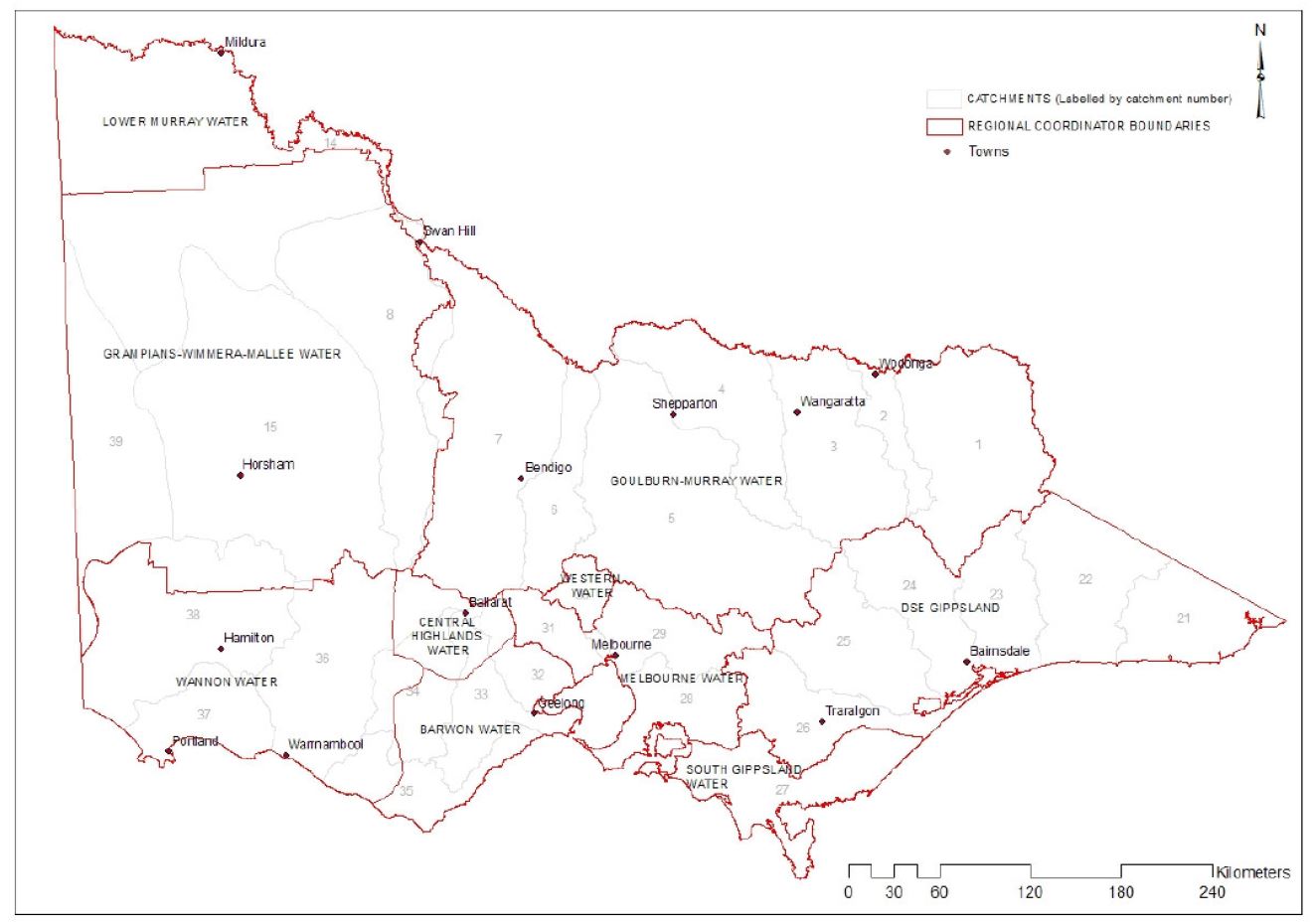
As Regional Coordinator, GWMWater coordinates the management of major outbreaks across these areas, while Local Water Managers (LWMs) monitor and manage local blooms under their own emergency plans.
This approach is outlined in the Blue-Green Algae Regional Coordination Plan, which is based on the Victorian Emergency Management Manual. The Plan covers:
- The role and responsibilities of the Regional Coordinator (GWMWater) and Local Water Managers (LWMs).
- How to prepare for, respond to and recover from a blue-green algae event.
- Reporting blue-green algae outbreaks.
View current supply blue-green algae outbreaks or rec lake and reservoir blue-green algae outbreaks.
![]() Blue-Green Algae Regional Co-ordination Plan (553 kB, 24 pages)
Blue-Green Algae Regional Co-ordination Plan (553 kB, 24 pages)
| For warnings for the Murray River, refer to algal information issued by the NSW Department of Primary Industries. |
Page 16 of 35